| |
ARCHAEOLOGICAL SURVEY OF ISRAEL
HAR KARKOM MAP
FOREWORD
The survey map of Har Karkom (HK) is the first of two maps, together with that of Beer Karkom (BK), which are under study since 1980 [1].
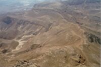
The interest of the present writer for the mountain which today has the name of Karkom, goes back to 1954. As a student he was carrying on a survey of rock art and came across a major concentration of rock art on a mountain in the southern Negev desert of Israel. The site was called Jebel Ideid, according to Bedouin guides, in Arabic the name may mean "Mountain of Celebration" or "Mountain of the Multitude". This mountain, fenced by precipices, is a high plateau of ca. Km 4x2 with two prominent hills at the centre. A focal characteristic is the flint gravel, or hammada, that covers vast surfaces of the site.
Around the mountain there are valleys crossed by wadis. The plateau and the valleys look like two separate worlds. The archaeological finds in each are different as well. The Palaeolithic sites are mainly concentrated on the plateau. In the BAC period (Bronze Age Complex, includes Chalcolithic, Early Bronze age and Middle Bronze age I) the plateau has a concentration of altars, pillars and other cult sites. The valleys have numerous remains of stone built basements of huts and of entire villages (likely to have inspired the Arabic name).
In 1980, as head of the Italian Archaeological Expedition to Israel, we came back to this mountain to start an archaeological survey in a cooperation project between the Centro Camuno di Studi Preistorici, the Israel Department of Antiquities and the Archaeological Survey of Israel, supported by the Italian Ministry of Foreign Affairs.
Meanwhile the mountain had changed its Arab name to the Israeli name of Har Karkom, which means "Mount Safran". It soon became clear that Har Karkom had been a religious high place in the past. In 1983, after four years of archaeological survey, we advanced the hypothesis that this mountain might be identified with the biblical Mount Sinai. The proposed identification opened up a wide debate which is still in progress.
With the present publication, the description of sites recorded during the survey becomes accessible to all. The debate may continue on the historical identity of this mountain, but being this a report on the survey, the specific aspects of historical geography are not discussed in the present volume. Here the main purpose is to provide the basic archaeological information on each site [2].
The present publication is the first full report of the sites. The area of Har Karkom has already been discussed in three volumes and numerous articles. A full bibliography of previous publications is provided in the following pages. The publication of The Mountain of God: Har Karkom, (Rizzoli, New York, 1986), I Siti a Plaza di Har Karkom, (Edizioni del Centro, Capo di Ponte, BS, 1989), Har Karkom In The Light of New Discoveries, (Edizioni del Centro 1993), provided information on specific aspects of the archaeological discoveries. Field work has since progressed, adding new evidence. The analysis of archaeological data, topography and exegesis, are all still in progress.
A further elaboration on the implications of the discoveries for the historical geography and Biblical studies is provided by "Esodo Tra Mito e Storia", (Edizioni del Centro, Capo di Ponte, BS, 1997). The proceedings of a Symposium, "Har Karkom e Monte Sinai - Archeologia e Mito" held in Milan in January, 1997 have been published (Comune di Milano, Settore Cultura e Musei, Civiche Raccolte Archeologiche, Milan, 1998).
Twenty years of field work in the areas of Har Karkom and Beer Karkom have produced the survey of well over 1300 archaeological sites out of which 636 are included in the Har Karkom map, and provide a general view on the density and character of human presence for each period.
Though Har Karkom is only a modest 487 meters above sea level, it dominates the surrounding Paran desert, the Araba Valley and beyond. The mountain is visible from the Edom mountains in Jordan, over 70 km away. Likewise it is visible from Jebel Arif el-Naqa, at an air distance of some 30 km Northwest, beyond the Egyptian border, and from Mizpe Ramon, at an air distance of some 40 km north. When looking at Har Karkom from the Paran desert, the mountain has a rectangular outline that imposes itself on the horizon. This is an obvious point of reference for travellers crossing the desert today as in the past.
Har Karkom is an area in extreme desert conditions. Over the entire map of 100 sq. Km there is not a single well or source. Rain is scanty averaging less than 50 ml annually between 1980 and 1990, and it is concentrating in the winter period. Rainy water is sporadically collected in natural pools which become dry within 30 days from the last rain. Only in one site the pool may still be wet in may. No water is available at the surface for over six monyhs a year. Under such conditions, any minimal change in water supply may vary the possibilities of subsistance in the area. Microclimatic variations may thus be responsible for the drastically alternated curve of density of archaeological sites (Fig. 1).
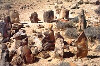
Perhaps it is significant that this mountain has been an important source of prime-quality flint in Palaeolithic times. Numerous Palaeolithic flint workshops have been recorded so far on the plateau. The archaeological evidence collected in previous years had led us to consider that Har Karkom became a holy place at the end of the Stone Age. The use of flint, at that time, as the material of primary daily use, was drawing to a close. However, flint continued to be used in the Early Bronze Age and later, especially for ritual purposes such as circumcision. The quantity of very large and refined tools, too heavy to be easily handled, may well hint at ritual uses. Two of the largest BAC scrapers weight more than five kilos each. Both of these have been found in context which seems to be ritual: site HK 65c and HK 53. One was standing up in front of a fireplace and the second was at the foot of an anthropomorphic orthostat.
The Palaeolithic "sanctuary" discovery in 1992 is changing previous views on the beginning of worship at Har Karkom. The flint industry found in the sanctuary belongs to what may be defined as the initial phase of the Upper Palaeolithic and is likely to be more than 35,000 years old. The site HK 86b is located on the eastern ridge of the Har Karkom plateau which dominates the Paran desert. About forty large boulders of flint with sinuous and provocative natural shapes were assembled there by early man. Most of them suggest anthropomorphic shapes and are about one meter high. Some of them are standing; others are fallen. On the ground of this area, which is about 400 m2, numerous flint implements have been found, along with a sizeable collection of flint pebbles having natural anthropomorphic and zoomorphic shapes. Some of them have occasional man-made retouchings, which modify the natural forms. Pebble drawings are also found , i.e., pebbles arranged in various patterns on the exposed palaeosoil, or fossil bed. The ground was probably covered by humus and vegetation in the Upper Palaeolithic. Sometimes the Har Karkom plateau was invaded by aeolic loess deposits which are still abundantly found in the crevices. Later, wind removed the loess not sealed off by the hammada deposits and brought back to surface the palaeosoil.
Besides the unique site called "Palaeolithic Sanctuary" (site HK 86b), the most evident cult sites on the plateau are mainly from the Chalcolithic and Early Bronze Age, a period which lasted 2500 years , referred to as BAC or Bronze Age Complex. In the surrounding valleys, at the foot of the mountain, several sanctuaries, alignments of menhirs and other cult structures from the same period have been recorded, as well as a few later ones. The discovery of the Palaeolithic site HK 86b indicates that the mountain had acquired sacrality much before it was previously believed.
Har Karkom was intensely occupied during the Palaeolithic by hunting clans that collected and worked fine-quality flint. The area was virtually abandoned in the Neolithic period (only eight sites are known). The Chalcolithic and Early Bronze Age (BAC) was a period of wide occupation, reflected in the numerous religious and burial sites on the mountain and the dwelling encampments at its base. Many sites count a consistent number of living structures. During this time Har Karkom was a place of vast cult activity. The tumuli contain secondary burials in which the human bones are not in anatomical position. The BAC period includes most of the cult sites, both on the plateau and in the surrounding valleys; it reflects an intense human presence. If we consider the quantity of cult sites, the mountain appears to have attracted people not just for agricultural or pastoral reasons.
The sites recorded at Har Karkom are providing a considerable documentation on the way of life, the social structure, the economy, the habits and the beliefs of desert people throughout the ages. The documentation based in the Har Karkom archives includes over 22,000 photographs, which may require years to analyse in all details. In this volume is presented an essential illustration to provide a general view of the survey results3.
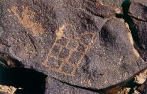
It was clear from the beginning of our survey that Har Karkom was a paramount cult centre in the fourth and third millennia BC: Har Karkom appeared as a kind of prehistoric Mecca where large groups of people came and built their camps at the foothills. Pillars, stone circles, geoglyphs, tumuli, altar-like structures, peculiar round platforms, which may be what the Bible refers to as bamoth, are all indications of religious activities. We may add to this the enormous amount of religious rock art (over 40,000), alignments of pillars, the remains on the plateau of a small temple, site HK 24a-b (a structure with a rectangular altar-like platform facing east) and several more at the foot of the mountain. Har Karkom presents a unique aggregation of evidence of religious activity during the BAC period (Bronze Age Complex).
On the plateau the ground is covered by Palaeolithic remains with hut floors, fireplaces and flint workshops practically untouched. It is unlikely that the multitudes of the BAC campsites at the foothill stepped on this ground. It rather seems that they had no access to the plateau which is likely to have been reserved to a very restricted number of people. An analogous situation is narrated in Exodus about the prohibition for the people to step on the mountain (Exod. XIX: 12-23). This may have been an habit for holy mountains.
After the BAC episode, the region was abandoned for most of the second millenium. Like in other areas of the Negev and Sinai, none of the recorded sites seem to date between 2000 and 1100 BC. No traces of human presence were found for the second part of the Middle Bronze, the Late Bronze Age and the beginning of the Iron Age. A new period of human presence starts in the Iron Age and in Hellenistic times. The human presence in the area explodes with an episode of large scale colonization during Roman and Byzantine times; it decreases but persists during the Islamic period.
THE SURVEY
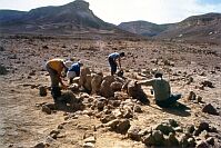
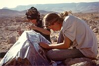
The area of the survey was carefully explored by survey teams. Aerial photographs of the area were obtained from the Israeli army, and were integrated by aerial photographic surveys previous to the systematic exploration of the ground. Enlargements of the photographs were carefully investigated to prepare the program of each campaign during 20 years of survey. All remains were recorded, included contemporary Bedouin encampments, and documented once again by field photographs, by plans and by drawings. Every finding, structure, settlement, material culture or rock art was codified and the data were processed by means of a computer-based data base for statistics.
The plans of the Palaeolithic sites, clearly visible as areas cleared of stones on the brown surface, were drawn; flint flakes, nuclei and implements were collected from selected sites for statistics and selected flint tools were collected for drawings. The stone structures were drawn; the pottery sherds were carefully collected. Rock art was monitored, traced and recorded.
The characteristic geomorphology of Har Karkom and its surrounding - a typical rock desert - leaves most findings on the ground surface: no stratigraphy is usually available; moreover, the chemical composition and the acidity of the ground do not allow ancient organic remains survive and only few 14C datings are available. In the Har Karkom area so far there is only one 14C dating and it is from a cave deposit. Thus, the sites have been dated exclusively on the basis of typology of the material culture, like flint implements and pottery.
The sites have been excavated in a few cases, like some tumuli, some hut floors and a rock shelter where stratigrapic elements were obtained.
In total, 636 sites were recorded in an area of 100 squared Km, reflecting transient character of settlements mainly of nomad people in every time, rather than extensive settlements.
Har Karkom was extensively settled during Palaeolithic age, during late Chalcolithic, Early Bronze age and beginning of the Middle Bronze age, later on during Roman-Byzantine period, many Nabataean agricultural instalments - accompanied by rock engravings and inscriptions, as well as by pottery sherds - having been found. Finally, several nomadic encampments of the Islamic period were also found, the site having been settled by Bedouin people until the early years fifties of this century. On the contrary, only few sites belonging to Epipalaeolithic or Neolithic ages were found, no Late Bronze age was recorded, and sporadic Iron age or Hellenistic sites were found. This is in agreement with other surveys in the Negeb area [Avni 1992:14*-19*] and probably reflects a worsening of the climate conditions. A careful investigation of the time/climate course since Lower Palaeolithic until Roman era in the whole region could probably help to clarify the phenomenon.
|
 Get the book for only 15. (you save 10.)